Burdett's Ordinary Archaeological Report, Block 17 Building 2COriginally entitled: "Archaeological Report on Old Foundations Found on "Bryan"and "Donegan" Lots, East Duke of Gloucester Street - Block 17, Lots 2 and 3 (Sites of Red Lion Inn and Burdette's Ordinary)"
Colonial Williamsburg Foundation Library Research Report Series - 1326
Colonial Williamsburg Foundation Library
Williamsburg, Virginia
1990
From: H. S. Ragland.
Subject: Archaeological Report on old foundations found on "Bryhn" and "Donegan" lots, East Duke of Gloucester Street -Block 17, Lots 2 and 3-(Sites of Red Lion Inn and Burdette's Ordinary).
Date: Williamsburg, Virginia, March 11, 1932.
Submitted herewith in an archaeological drawing showing remains of old foundations recently uncovered by excavations on the above described lots, which are parts of the original colonial lots Nos. 57 and 58. Their location has been determined by survey on the ground in accordance with lines indicated by old foundations, old deeds, maps and records in the Research Department. As deeds recorded in York County Court House in 1765 clearly show that the outside line of the eastern wall of Dr. James Carter's brick house was on the eastern line of lot # 53, and the foundation of the house was found and identified, thus fixing definitely on the ground the eastern line of lot # 53, I have used it as a base line in laying off the other colonial lots in block # 17, (1/2 acre lots - 82½ feet x 264 feet). The colonial property line between lots # 57 and # 58, thus determined, is about a foot west of the modern property line between the "Bryhn" and "Donegan" lots. (See archaeological 2 drawing and sketch also submitted herewith showing colonial lots in the block. -See archaeological drawing and report dated January 5, 1931, on foundations found between Raleigh Tavern and "Kinnamon" building, which includes the James Carter foundation).
Deeds and records in York County Court House show that Thomas Penman leased lot # 57 and operated an Inn (apparently the Red Lion) there, and that he brought suit in 1743, against John Burdette, the owner of lot # 58 for trespass, and won the suit, the surveyor's plat and statement showing that eight feet of Burdette's house was built on Penman's lot.
Foundation "A" (hatched thus  on the plan) uncovered after the Donegan house was pulled down, apparently is the foundation of Burdette's house, for the major portion of it is on Lot # 58 and about 6 feet of it on lot # 57 a fairly close check to the eight feet recorded in the suit. Foundation "A" was cut through (and in places removed) to make room for later construction and, as will be seen on the plan, all of the later buildings were erected entirely within the lines of lot # 58. Remains of the foundation of the second house are hatched thus
  , and the third thus
  , which is the foundation of the recently removed Donegan House. Modern changes in the Donegan foundations are shown thus.
 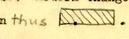 .
.
At "E" part of an old foundation of a probable outbuilding of the period of the second house was found.
The outbuilding foundation found at "K" appears to be 3 very old.
About 3 feet east of the present Lee house and on colonial lot # 57, remains of a very old foundation, probably part of the foundation of Penman's house (The Red Lion) were found. Brick work at "G" was added apparently when a small cellar was dug out under the original building, "F".
At "H" a large chimney foundation and the Southwest corner of an outbuilding were found. The Northwest corner and North wall of the foundation were probably removed to make room for outbuilding "J". It, in turn, was undoubtedly removed before the well was dug. A fragment of old foundation was found at "I".
Herbert S. Ragland
In charge of Archaeological Excavations.
HSR/vbl
Re: Report of August 27, 1930.
Perry, Shaw and Hepburn
141 Milk Street
Boston, Massachusetts
Attention: Mr. Robert C. Dean
Dear Mr. Dean:
In reply to your letter of April 8th regarding the report of August 27, 1930, we would like to refer you to the later report, October 14, 1930, which states that the August report was prepared before work in the York records was completed and some of the data was superseded by this new evidence.
Both reports were made without reference to any excavation, as they were made in order to indicate where excavations should be made; the site of the Red Lion Inn being mistakenly believed to be under the so-called Donnegan house. Evidence from deeds, insurance policies, standing buildings, colonial lot lines and maps was used and the crude diagram issued with the report was made.
Since the Restoration does not own either the Vaiden House or the Lee House, excavation between these two will be impossible. However the thirty-six foot dimension between the Lee and Vaiden house was determined by actual survey of the two standing buildings. The little house between the Lee and Vaiden houses was torn down about twenty years ago and was unquestionably between the two. If your calculations from the little photograph are based on this thirty-six foot dimension they are as accurate as this method of calculation would make them. The house, like many dormered houses in town, was extremely small and was so described by tenants. The evidence of the photograph and of the thirty-six feet is indisputable, so the dormers will have to be fitted to a building of less than thirty-six feet.
Although the excavations have been made at the Donnegan house, and both the Bryhn and Donnegan houses have been removed, drawings have not been issued. Mr. Ragland, who is in charge of excavations, reports that the architects suggested delaying this 2 report until a number of more pressing ones could be made. When this is done copies will be sent to the Boston office immediately.
In general historical reports are issued before excavations are made to indicate where excavations should be started. They are at all times subject to the limitations of historical evidence, that is the dimensions as given in insurance policies and records are liable to accumulate which will change or substantiate other evidence. In either case an effort is made by this department to issue such data to supersede an incomplete report. When excavations are made separate reports are issued on these excavations showing to what extent the historical and archaeological evidence check.
Since large amounts of new data are being accumulated we are pleased to have questions brought to our attention. Please write us on any point which seems doubtful and we will issue all available data.
Very truly yours,
Harold R. Shurtleff, Director
Department of Research & Record.
hdb/ab
Letter by: Helen Bullock
cc: P. S. H., Williamsburg.
Mr. Thomas Mott Shaw
Perry, Shaw & Hepburn
141 Milk Street Boston, Mass.
Dear Mr. Shaw:
At Mr. Macomber's request I sent you several days ago the archaeological drawing of the foundations found on the "Bryhn" and "Donegan" lots. Enclosed is a brief report concerning the foundations and a small plan showing the present lots and colonial lots, as I have deduced them, in Block 17, which I think proves that the oldest foundation found on the site of the Donegan house, is the foundation of Burdette's ordinary.
Also, in a separate package, I am mailing you three more complete Palace foundation drawings --No. 5, (terrace steps, cemetery and garden walls), No. 7, Sections, and No. 8, Elevations of the Palace Foundation Walls.
You have already drawings Nos. 1, 2, 3, and 4.
Yours very truly,
Herbert S. Ragland
HSR:mrm
BOSTON March 17, 1932.
CONCERNING Bryn & Donnegan Excavation
Perry, Shaw and Hepburn,
Williamsburg, Virginia.
Attention: MR. RAGLAND
Dear Mr. Ragland:
Thank you for your report on the Bryhn & Donnegan foundations and the map of Block 17 showing Colonial Lot Lines.
In connection with the map, I notice you state that you took as a point of departure for laying out the Colonial lots, the east wall of the James Carter Building and that you had an old deed to guide you in this conclusion. I wonder if this is an absolute certainty because your layout brings the first lot line, west of Carter's through the Kinnamon Store Building which is, of course, an early Colonial Building. To the east of Carter's, the line passes through the East Wing of the Raleigh Tavern. On account of these two conditions but without knowing the source of your information, I wonder if the following would not be a more reasonable supposition:
Place the Lot Line which now coincides with the east wall of Carter's Shop on the west wall of the Raleigh Tavern. The Lot Line to the west would then clear the Kinnamon Store and the Lot Line to the east would clear the Raleigh Tavern Wing and by plotting the Colonial lines to the east of this point at 82 1/2 feet per lot, the lot line intersecting the Burdette foundation, comes exactly 8 feet east of the west wall of the old Burdette Foundation just as described in the damage suit. Also the old line west of the Red Lion foundation scales exactly the same as the distance shown on the little drawing in the Yorktown Records which was evidently made by an engineer at a scale of 40' - 1".
These are all quite significant facts and I believe they are worthy of further investigation.
Yours very sincerely,
Thomas Mott Shaw
PERRY, SHAW AND HEPBURN
TMS:LS
Attention: Mr. Shaw
RE: Colonial Lot Lines - Block 17.
Perry, Shaw & Hepburn
141 Milk Street Boston, Mass.
Dear Sirs:
Replying to your letter of March 17th concerning the Bryhn-Donnegan foundations and the colonial lot lines in Block 17, I find after further investigation and study that it is practically impossible, with many gaps in the records, to adjust the locations of the colonial lot lines so that they conform to all the deeds and records found. However the attached layout may be useful.
I have laid out the colonial lots east and west from the east line of Kinnamon's store, which I have taken as a colonial lot line. This, perhaps, is a supposition, but I think the whole layout reconciles the greatest number of facts. The lots are 821/2' wide; the Kinnamon building is entirely on lot 52, the east line of the building coinciding with the east line of the colonial lot, also the east line of the present lot; all the Craig and Carter foundations are entirely within the lines of lot 53; the Raleigh Tavern is on lot 54; and the line between lot 57 and lot 58 falls almost exactly 8' east of the west wall of the old Burdette foundation, just as it is recorded in the damage suit. Also the line between lots 53 and 54, you will notice, bisects the alley between the Carter foundations and the Raleigh Tavern. A jointly owned alley there seems logical to me, for both owners must have used it in common.
However (and this is the strongest point against the whole layout) such a location is not indicated by the Carter deeds (see my report on the "Foundations between Kinnamon store and Raleigh Tavern" dated January 5, 1931, a copy of which I am sure is on file in your office). Another objection to the layout is that the colonial east line of Botetourt Street falls 64.75' east of the William Carter brick house foundations instead of 66'. All the records indicate a 66' street, and the east line of the William Carter foundations should be the west line of the street as the foundation is 80' long, and 2½' of the western part of the lot was sold to the adjacent owner, accounting for the whole frontage of that lot.
2On the other hand, to support the correctness of the layout, there is evidence that parts of many colonial lots were sold, consequently changing the original lot sizes and lines. Therefore where a lot line crosses a colonial house (such as the Lee House) it should not be considered as evidence against the layout, but rather that the original lot lines were changed there before the house was built.
Very sincerely yours,
Herbert S. Ragland
HRS:mrm
cc: P.S. & H., WMSB.
Mr. Shurtleff
 Archaeological Survey of Foundations on "Bryhn and Donegan" uncovered in Williamsburg, Virginia, 1930-31 (Sites of Red Lion Inn and Burdettes Ordinary) - oversized image
Donegan House Details of Excavations - oversized image
 Red Lion Inn. site: Bryn House. First Floor Plan Scale ¼"=1'0" June 14 - 1932 P.S.&H.
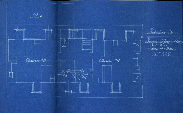 Red Lion Inn. Second Floor Plan. Scale ¼"=1'0" June 14 - 1932. P.S.&H.
[oversized image]